Diplomprosjekt
Høst 2022
Institutt for urbanisme og landskap
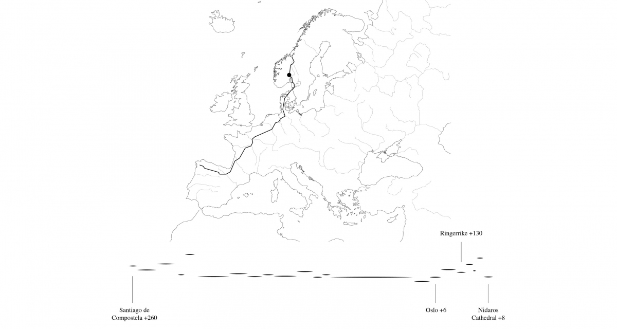
The project engages with the geographic area of the clayland valley of Ringerike-Hole to reframe its narrative and revalorise the valley. Ringerrike-Hole is located on a plateau behind the Oslo volcano belt, a sparely inhabited machine-operated landscape valuable in terms of agriculture, forestry and hydropower. The valley is characterised by its marine clays, surrounding gneiss mountains, meandering rivers, and vast and softly sloping agricultural fields. Village clusters populate the slopes and river islands. Hill-top churches, ancient ruins and burial mounds shape the cultural landscape. Meanwhile, sunken birch swamps, acres of salad, groves of apples and magnificent long forested ridges inundate the landscape with typologies of green.
The project uses the Gudbrandsdalen Pilgrim’s Route, established in the 11th century, which runs through the valley on its way to Nidaros cathedral in Trondheim, to catalyse a sequence of rural projects. The regenerative gardens engage with local farming conditions related to agricultural run-off, soil preservation and biodiversity whilst accumulating in the pilgrim experience - to have a drink, breakfast, rest and contemplate.
Indeed, the project suggests that national and global initiatives like the Pilgrim’s Route can exceed their programmatic goals, transcending project boundaries to inspire landscape improvement and celebration. It is a response to the current conflicting pressures of urbanisation through the expansion of the greater Oslo region. Moreover, the more prevalent exhaustive agricultural practices deplete local soil and water conditions, whilst compromising scale, identity and history within the valley.
The diploma approaches the valley with a variety of methods:
- tracing historical cartography, aerial imagery and mapping patterns
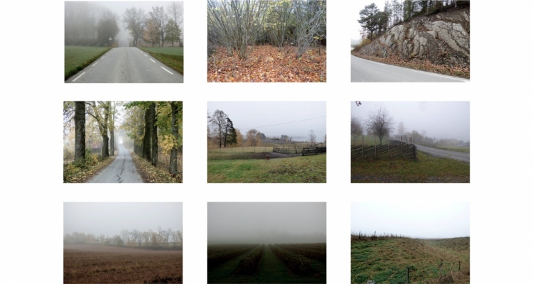
- walks, photography and documentation of site atmospheres, materiality and spatiality
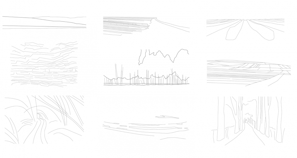
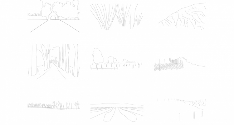
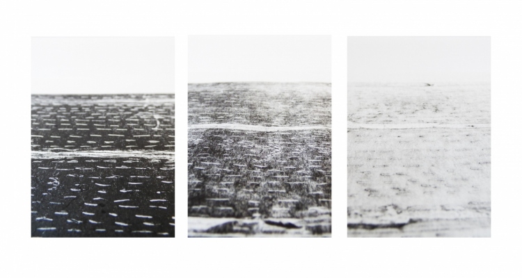
- creating abstractions and translations of spatial conditions on site with sketch and print
- using formal and material site findings by adapting abstractions onto three sites
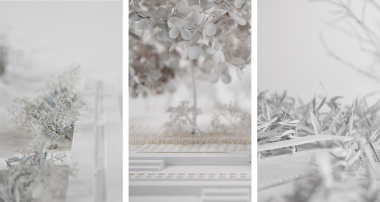
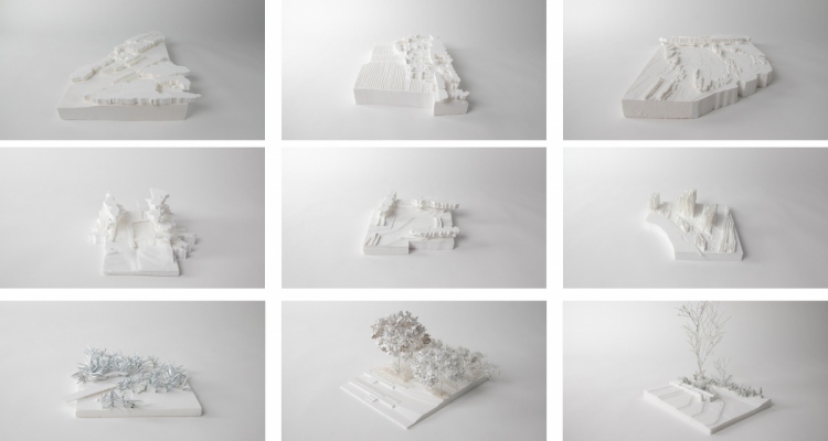
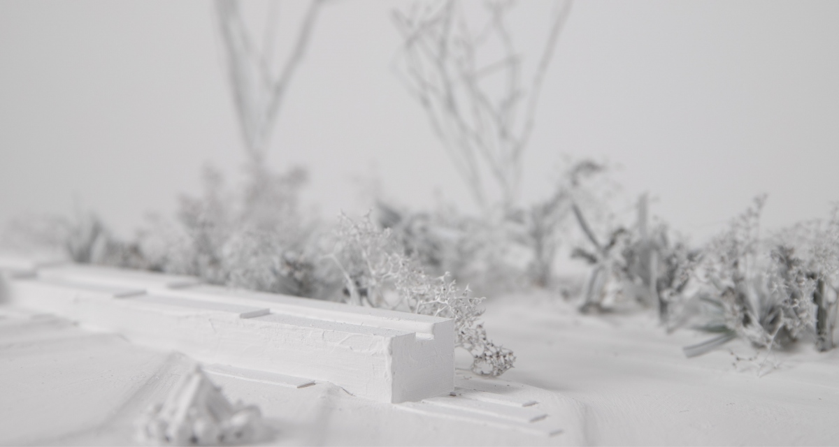
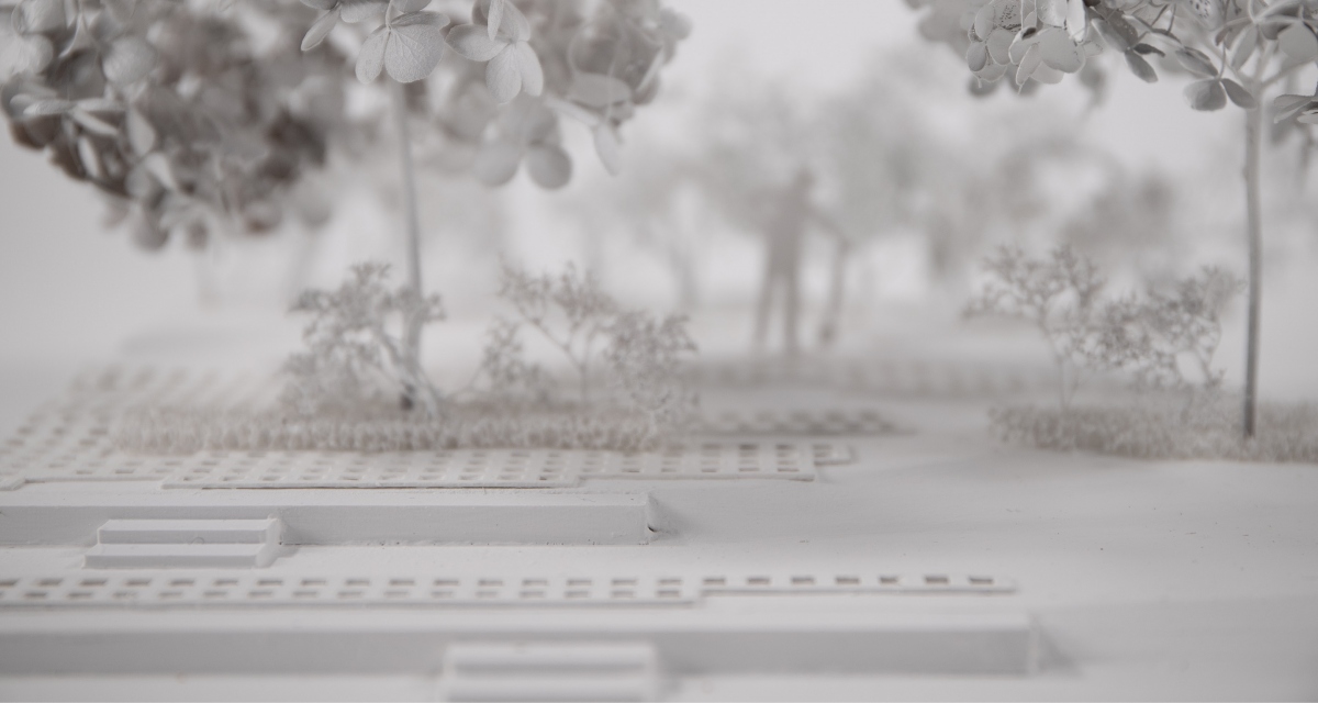
- volumetric foam models to inform space, planting and usage
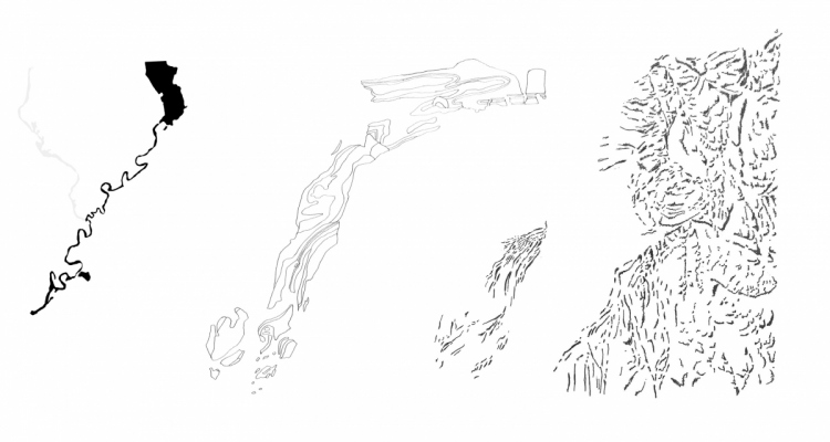
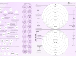
The project works primarily on two scales: by proposing a guiding image to describe the territorial patterns as characters in the valley with specific ecological and spatial qualities. The project identifies five characters to point out landscape entities that should be preserved and developed for the valley to become more biodiverse and water-sensitive: the Limestone veil, the Mosaic island, the Meander ghosts, the Ravine hem and the Rippling terraces.
The second scale addresses the spatial qualities of each territorial character. From the Limestone Veil, the Mosaic Island and the Meander Ghosts, the roughness of the limestone, multiplicity of fences and birch thickets are reinterpreted through print-making. These conditions are then used to inform the atmospheres of the gardens themselves, the first three encounters of the pilgrim’s way.
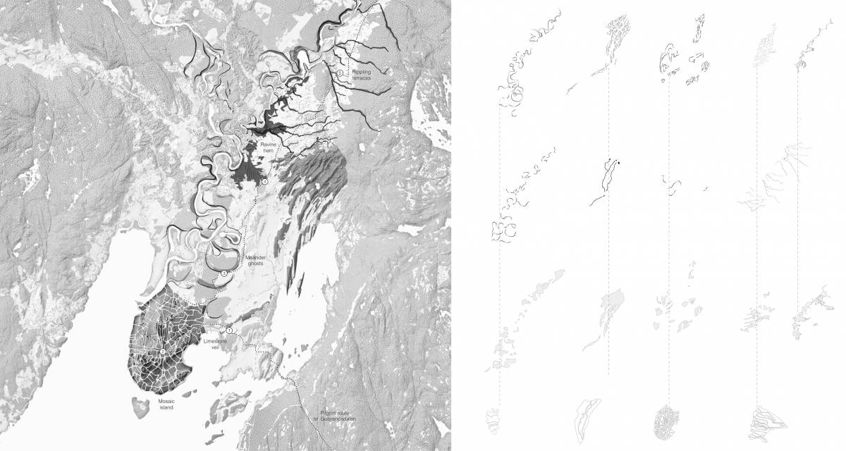
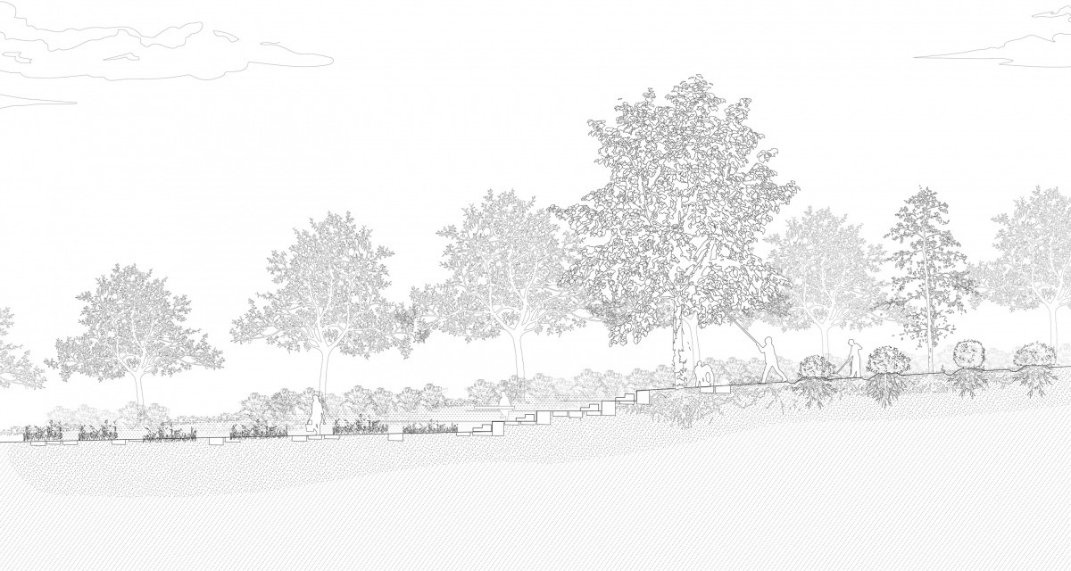
The Limestone Veil - Ridge Garden
Intense internal folding of the Cambo-Silurian limestone bedrock has created chains of forested cuestas on the vast valley plains. Transplanting patterns of the layered limestone, the experience of passing through these occasionally opening and obscuring formations is intensified by a repeating the forest ridge typology. The first intervention underlines the direction of the forest ridges and the exposed stratified rock, by restoring a creek running parallel to the cuestas.
Aligned with existing forest edges and drainage falls, the Ridge Garden trades off a grain field edge in exchange for treating the local agricultural run-off. The process of the folding bedrock appears in the garden at a variety of heights - water, planters, canopies, limestone retaining walls and blocks to walk along, a trout to lead drinkable water to the pilgrim.
The Mosaic Island - Linear Fruiticum
Located on an undulating chalky half-island, the Pilgrim’s Route passes cultural heritage site Røysehalvøya. A mosaic of varied shaped and sized fields for fruit, vegetable and crops, the dense web of plotlines accomodate ravines and cobbly hills whilst imposing onto the gentler slopes. Lines of ownership and order are central in shaping the spatial experience of agricultural areas, however, widespread land consolidation due to improved farming machinery and pressure to produce food more effectively have caused a disappearance of visible field boundaries, hedges, ditches, tree alleys and embankments.
The project restores the visibility of plot lines by reconstructing field margins, hedges and tree corridors, thus reintroducing a soft networks for water, people and species. The experience of passing through a mosaic of partially enclosed rooms is intensified on a sunny slope with the second encounter on the pilgrim’s way, the Linear Fruiticum. This garden invites one to pick from a network of fruit trees and berry bushes planted around clover fields, accumulating in the Fruiticum plaza - a pitstop to enjoy the picked fruits in, an agora for locals to experience the spring blossom or autumn harvest.
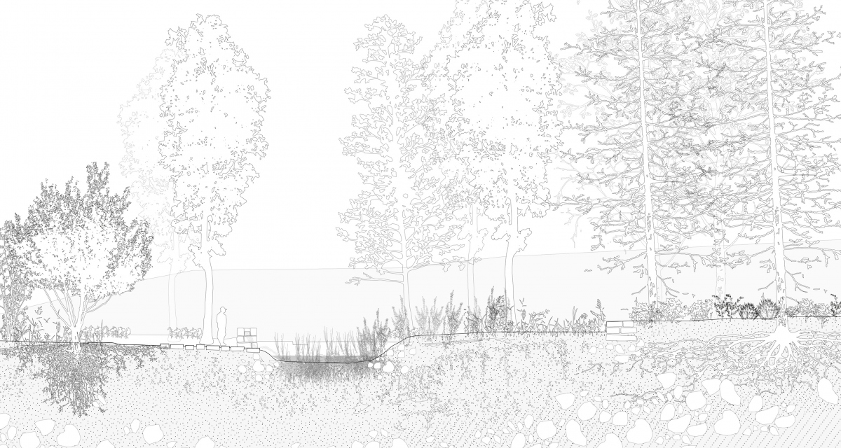
The Meander Ghosts - Reedy Bends

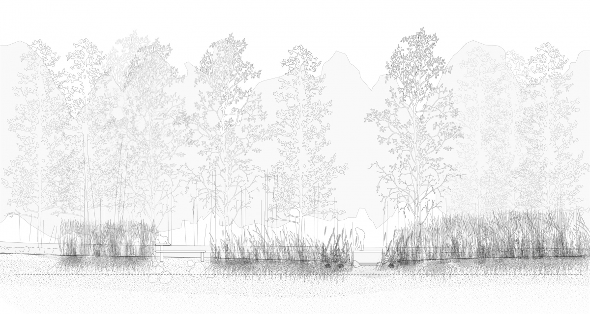
Slow and powerful, Storelva erodes and deposits onto a soft bed of river clays occupied by farms, fields and wetlands. As the river continues to meander, its ‘ghosts’ manifest in small river hooks, river terraces, radial flood patterns. Though 25% of the delta is occupied by farmland, the infiltration capacity of the dense clay is poorly benefited. Therefore, by following the flood patterns of a vast field next to Helgeland’s village, the cultivation patterns on a convex field bend into a sanctuary of marsh beds, garden meadows and raised platforms.
Integrated into today’s bright green and deep purple lines of cabbages, the Reedy Bends will collect and hold water which today floods and destroys. The repeating radial bends amplify and draw attention to the deep-time movement. High grasses offer a place of seclusion and contemplation for the pilgrim.
Conclusion
As the population of Ringerike-Hole is predicted to increase from 30,000 to 40,000 by 2030, and sprawling urbanisation threatens soil health, local ecosystems and renders new neighbourhoods similar, the project stresses that landscape patterns hold the strength to organise and inspire unexpected spatial conditions. The project extracts material from the site and utilizes extensive research to conceive a strategic landscape project. In developing the method of collection, abstraction, transplant, and translation models and drawings become sequential parts of an iterative process, thus making the process the project.

Sarita Poptani / sarita.poptani@gmail.com / saritapoptani.com
The project uses the Gudbrandsdalen Pilgrim’s Route, established in the 11th century, which runs through the valley on its way to Nidaros cathedral in Trondheim, to catalyse a sequence of rural projects. The regenerative gardens engage with local farming conditions related to agricultural run-off, soil preservation and biodiversity whilst accumulating in the pilgrim experience - to have a drink, breakfast, rest and contemplate.
Indeed, the project suggests that national and global initiatives like the Pilgrim’s Route can exceed their programmatic goals, transcending project boundaries to inspire landscape improvement and celebration. It is a response to the current conflicting pressures of urbanisation through the expansion of the greater Oslo region. Moreover, the more prevalent exhaustive agricultural practices deplete local soil and water conditions, whilst compromising scale, identity and history within the valley.
The diploma approaches the valley with a variety of methods:
- tracing historical cartography, aerial imagery and mapping patterns
- walks, photography and documentation of site atmospheres, materiality and spatiality
- creating abstractions and translations of spatial conditions on site with sketch and print
- using formal and material site findings by adapting abstractions onto three sites
- volumetric foam models to inform space, planting and usage
The project works primarily on two scales: by proposing a guiding image to describe the territorial patterns as characters in the valley with specific ecological and spatial qualities. The project identifies five characters to point out landscape entities that should be preserved and developed for the valley to become more biodiverse and water-sensitive: the Limestone veil, the Mosaic island, the Meander ghosts, the Ravine hem and the Rippling terraces.
The second scale addresses the spatial qualities of each territorial character. From the Limestone Veil, the Mosaic Island and the Meander Ghosts, the roughness of the limestone, multiplicity of fences and birch thickets are reinterpreted through print-making. These conditions are then used to inform the atmospheres of the gardens themselves, the first three encounters of the pilgrim’s way.
The Limestone Veil - Ridge Garden
Intense internal folding of the Cambo-Silurian limestone bedrock has created chains of forested cuestas on the vast valley plains. Transplanting patterns of the layered limestone, the experience of passing through these occasionally opening and obscuring formations is intensified by a repeating the forest ridge typology. The first intervention underlines the direction of the forest ridges and the exposed stratified rock, by restoring a creek running parallel to the cuestas.
Aligned with existing forest edges and drainage falls, the Ridge Garden trades off a grain field edge in exchange for treating the local agricultural run-off. The process of the folding bedrock appears in the garden at a variety of heights - water, planters, canopies, limestone retaining walls and blocks to walk along, a trout to lead drinkable water to the pilgrim.
The Mosaic Island - Linear Fruiticum
Located on an undulating chalky half-island, the Pilgrim’s Route passes cultural heritage site Røysehalvøya. A mosaic of varied shaped and sized fields for fruit, vegetable and crops, the dense web of plotlines accomodate ravines and cobbly hills whilst imposing onto the gentler slopes. Lines of ownership and order are central in shaping the spatial experience of agricultural areas, however, widespread land consolidation due to improved farming machinery and pressure to produce food more effectively have caused a disappearance of visible field boundaries, hedges, ditches, tree alleys and embankments.
The project restores the visibility of plot lines by reconstructing field margins, hedges and tree corridors, thus reintroducing a soft networks for water, people and species. The experience of passing through a mosaic of partially enclosed rooms is intensified on a sunny slope with the second encounter on the pilgrim’s way, the Linear Fruiticum. This garden invites one to pick from a network of fruit trees and berry bushes planted around clover fields, accumulating in the Fruiticum plaza - a pitstop to enjoy the picked fruits in, an agora for locals to experience the spring blossom or autumn harvest.
The Meander Ghosts - Reedy Bends
Slow and powerful, Storelva erodes and deposits onto a soft bed of river clays occupied by farms, fields and wetlands. As the river continues to meander, its ‘ghosts’ manifest in small river hooks, river terraces, radial flood patterns. Though 25% of the delta is occupied by farmland, the infiltration capacity of the dense clay is poorly benefited. Therefore, by following the flood patterns of a vast field next to Helgeland’s village, the cultivation patterns on a convex field bend into a sanctuary of marsh beds, garden meadows and raised platforms.
Integrated into today’s bright green and deep purple lines of cabbages, the Reedy Bends will collect and hold water which today floods and destroys. The repeating radial bends amplify and draw attention to the deep-time movement. High grasses offer a place of seclusion and contemplation for the pilgrim.
Conclusion
As the population of Ringerike-Hole is predicted to increase from 30,000 to 40,000 by 2030, and sprawling urbanisation threatens soil health, local ecosystems and renders new neighbourhoods similar, the project stresses that landscape patterns hold the strength to organise and inspire unexpected spatial conditions. The project extracts material from the site and utilizes extensive research to conceive a strategic landscape project. In developing the method of collection, abstraction, transplant, and translation models and drawings become sequential parts of an iterative process, thus making the process the project.
Sarita Poptani / sarita.poptani@gmail.com / saritapoptani.com